Long-lost U.S. Air Force Bomber Located in Bermuda

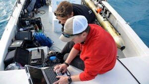
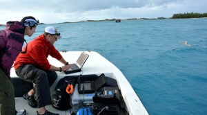
Gretchen Goodbody-Gringley (left), Art Trembanis (right) and his students—who were visiting BIOS for a field course in geology and oceanography—used the AUV and a remotely operated vehicle (or ROV) to conduct a seafloor mapping expedition in Castle Harbor, Bermuda.
The crash and subsequent disappearance of a U.S. Air Force B-24 bomber nearly 74 years ago has been resolved with the discovery of wreckage in Bermuda by a team of scientists, students, and underwater robots.
On February 6, 1945, at 10:20p.m., a B-24 bomber took off from the end of the north/south runway and, soon after, crashed into the waters of Castle Harbor. The heavily loaded plane carried a total of nine crewmen as it embarked on a routine ferry flight from Bermuda to Lagens, Portugal.
Within minutes of the crash, rescue operations were underway in conditions of near total darkness, high winds, and heavy waves. By the time rescue operations ceased four and a half hours later, four crew members had been rescued alive, two were pronounced dead, and three remained missing.
For more than seven decades the wreckage of the B-24 bomber remained unaccounted for, its final resting place obscured by the layers of sediment and often-murky waters of Castle Harbor. That is, until the University of Delaware’s (UDel) Art Trembanis mobilized a collaborative team of marine scientists, students, and ocean science technology to locate the missing aircraft.

Art Trembanis (right) is an Associate Professor in the College of Earth, Ocean, and Environment. He recently taught an environmental field robotics course and suggested to school officials that underwater robots accompany him and a group of students to the Bermuda Institute of Ocean Sciences (BIOS) for a 3-week study abroad course in geology and oceanography. Here, Trembanis and UDel doctoral student Stephanie Dohner launch the AUV from a BIOS vessel in Castle Harbor.
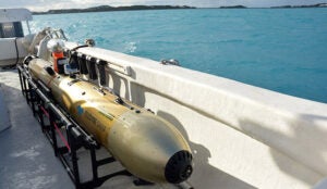
Trembanis was made familiar with the case of the missing bomber and the historical significance by Mark Moline, director of the School of Marine Science and Policy at UDel. Moline provided the funds for an autonomous underwater vehicle (an airplane-shaped robot, also known as an AUV) and a remotely operated vehicle (a tethered robot, also known as an ROV, controlled remotely by scientists aboard a ship) to make the trip to Bermuda.
“With this technology, I was able to design a real-life educational experience for my students,” Trembanis said. “I gave them the historical accounts on the bomber and had them work as a team to plan and execute a search and mapping mission in Castle Harbor.”
Trembanis also reached out to Philippe Rouja, Custodian of Historic Wrecks for the Bermuda Government, to discuss the mission and obtain more information on the potential wreck location and surrounding environment.
“Since that area had been dredged multiple times, I thought the plane would’ve been discovered already,” Rouja said. “But since Art [Trembanis] was doing this as a fully-funded field school component, it was hard to pass up the opportunity to search for this piece of history.”

The autonomous underwater vehicle, or AUV, that Trembanis, Goodbody-Gringley, and their teams used to help identify wreckage on the seafloor. AUVs are untethered (not connected to a vessel at the surface) and can be controlled remotely by technicians on support vessels or even back in the laboratory.
On Friday, January 11, 2019 Trembanis and his students, along with Rouja and BIOS researchers and technical divers Gretchen Goodbody-Gringley, Alex Chequer, and Alex Hunter, used a side-scan sonar mounted on the AUV to map an area of the seafloor.
The team chose to search a dredged portion of the bottom, located slightly deeper than the surrounding patch reefs, on the assumption that the plane might have sunk out of view over time. By running the AUV back and forth over the search area in a lawnmower pattern, a fairly detailed map of seafloor topography is produced.
Sure enough, there, in 50 feet (15 meters) of water, just a few hundred meters from the runway, was an airplane propeller and a portion of the wing. The AUV also recorded long shadows, which indicate a larger structure with higher relief, suggesting the plane might be oriented more vertically than if it was laying flat on the bottom.
The original plane, more than 67 feet (20 meters) in length and with a 110 foot (33 meter) wingspan, is less intact than the group was hoping for, but—as Trembanis points out—they are interested in more than just the plane itself.
“The B-24 was one of the most widely produced planes ever, so this isn’t a huge historical find,” he said. “What we’re really interested in is locating wreckage to help close cases of missing air crew.”
After the initial discovery, Trembanis received additional historical accounts from Mark Guishard, director of corporate and community relations at BIOS, recounting aircraft history in Bermuda. These accounts indicated that a salvage effort was conducted shortly after the initial crash and explains why the exploration team only encountered a few propellers and a portion of the wing. They also helped inform the data mapping process and provide information necessary to officially close the case.
For Trembanis and his team, this means working closely with colleagues and both the Bermuda and U.S. Governments to report the finding and determine what the next steps are to be followed. At the same time, Rouja is keen to conduct additional dives to map the historic wreck and capture details of the site.
