Sea Surface Temperature Oscillations at Hydrostation 'S'
The following figures show how sea surface temperature (SST) at Hydrostation ‘S’ oscillates over periods of several time scales. The data set has, thus far, revealed oscillations on annual and approximately semi-decadal to decadal time scales.
The regular seasonal pattern in SST at Hydrostation ‘S’ is shown below. The black line is the average of all temperature data (x) available in the time series from 1955 through 1997 for each month. The two dotted red lines (- -) show the maximum and minimum temperatures observed over this time for each month. Error bars are based on standard deviation values.
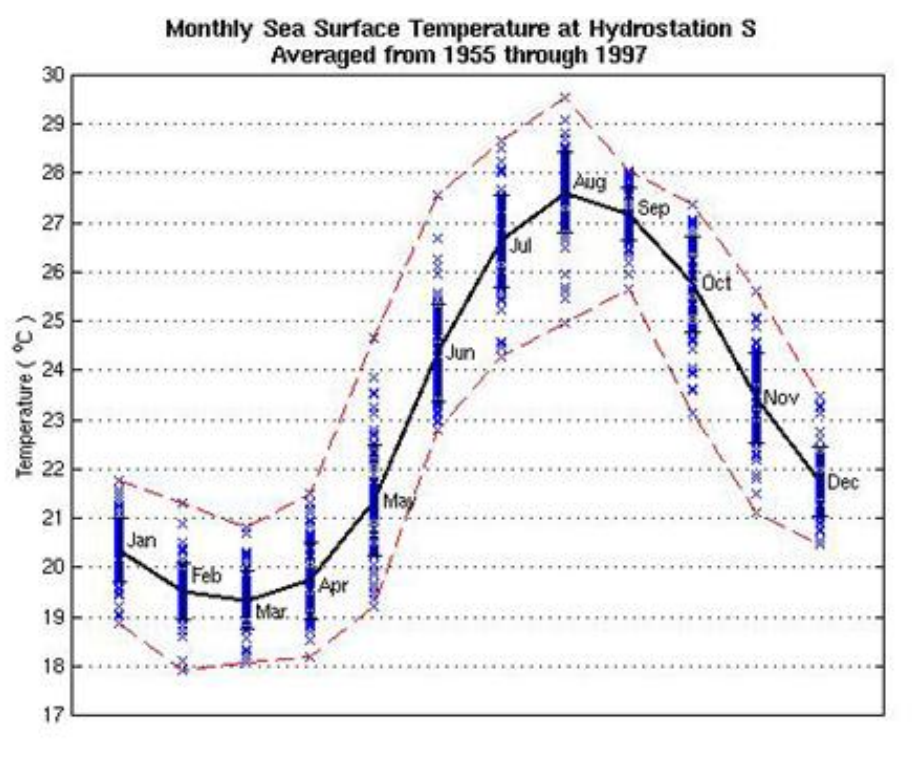
These are the data used to create the plot above with additional information on the dates of observed maximum and minimum temperatures, as well as the number of samples used to calculate the mean for each month.
| Month | Mean Temp | Max Temp yr/mo/day | Max Temp | Min Temp yr/mo/day | Min Temp | STD | n |
|---|---|---|---|---|---|---|---|
| January | 20.35 | 91/01/07 | 21.75 | 82/01/30 | 18.85 | 0.66 | 61 |
| February | 19.53 | 90/02/02 | 21.30 | 70/02/23 | 17.93 | 0.58 | 68 |
| March | 19.33 | 97/03/06 | 20.81 | 69/03/24 | 18.07 | 0.59 | 59 |
| April | 19.74 | 86/04/22 | 21.48 | 64/04/07 | 18.20 | 0.78 | 67 |
| May | 21.36 | 82/05/26 | 24.68 | 67/05/02 | 19.21 | 1.12 | 71 |
| June | 24.37 | 94/06/29 | 27.58 | 61/06/07 | 22.81 | 1.00 | 73 |
| July | 26.64 | 91/07/29 | 28.65 | 70/07/02 | 24.28 | 0.93 | 79 |
| August | 27.62 | 92/08/19 | 29.54 | 57/08/07 | 24.97 | 0.82 | 80 |
| September | 27.19 | 60/19/15 | 28.06 | 95/09/01 | 25.66 | 0.54 | 64 |
| October | 25.75 | 70/10/05 | 27.38 | 84/10/18 | 23.14 | 0.98 | 64 |
| November | 23.45 | 71/11/01 | 25.60 | 84/11/30 | 21.12 | 0.92 | 80 |
| December | 21.74 | 58/12/02 | 23.49 | 70/12/15 | 20.47 | 0.71 | 52 |
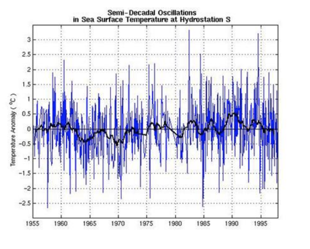
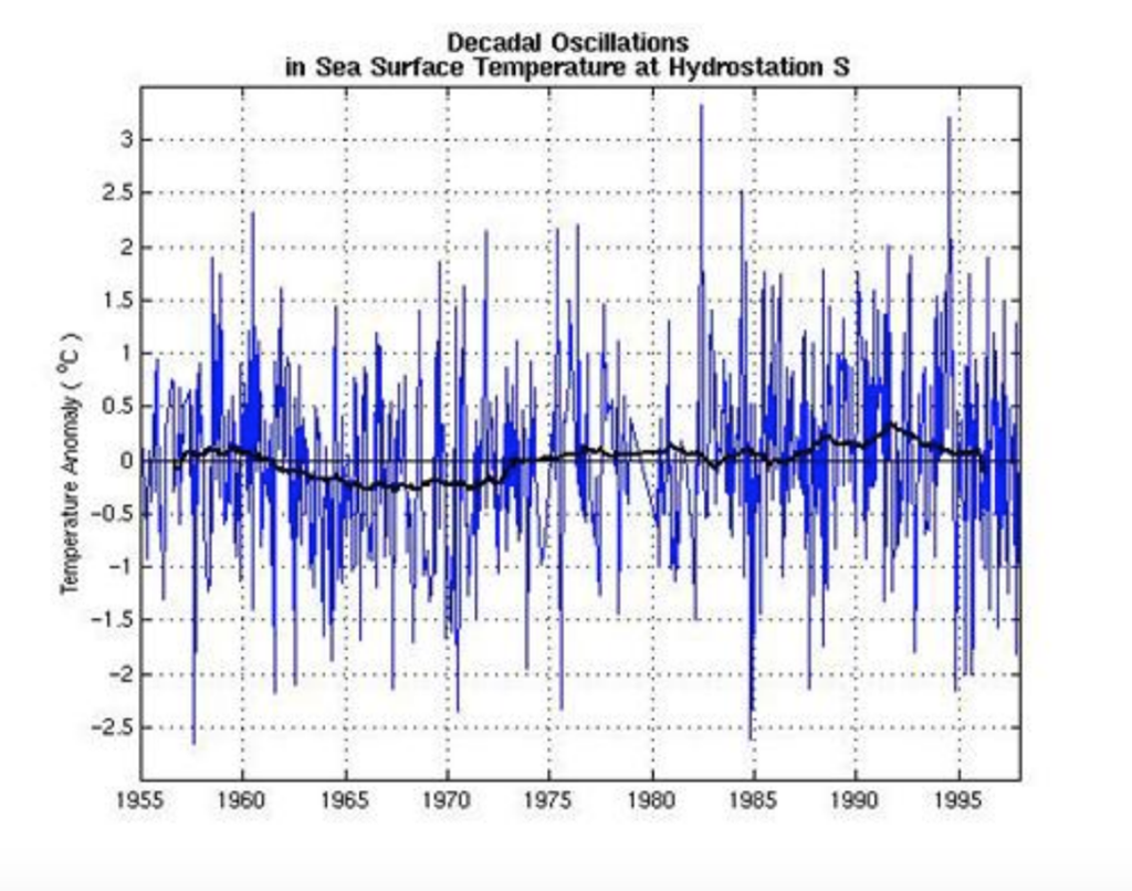
Two predominant long term oscillations in SST have been observed at Hydrostation ‘S.’ The noisy blue lines ( -) below are identical in both figures and are seasonally normalized SST anomalies. A lo-pass filter was run on these normalized anomalies to produce the overlying black lines ( -) which emphasize the longer term oscillations.